


BEING a harbinger for environmental policies, California on Monday, August 27, published a comprehensive assessment outlining the risks of global warming that are threatening the state.
Titled as California’s Fourth Climate Change Assessment, the assessment is the fourth to have been put out by the state since 2006 when former California Governor Arnold Schwarzenegger called for an assessment before signing the Global Warming Solutions Act. The act was the first to require in law, a sharp reduction of greenhouse gas emissions.
“In California, facts and science still matter,” said California Governor Jerry Brown on the recent assessment. “These findings are profoundly serious and will continue to guide us as we confront the apocalyptic threat of irreversible climate change.”
While many in California may be aware of the climate changes shown by city smog and increasing wildfires, environment advocates are seeing the assessment as holding weight against the federal government’s opinions on climate politics, such as the Trump administration’s efforts to rid climate change regulations meant to curb pollution from automobiles and coal-fired power plants.
The assessment relied on over 40 peer-reviewed reports detailing the impact of climate change on the California’s infrastructure, people, and natural systems.
Rising temperatures
The assessment projects that by 2100, the average annual maximum daily temperature will have increased by 5.6 to 8.8 degrees, depending on greenhouse gas emission reductions.
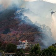
As wildfires hit both Southern and Northern California areas, the report found that the average area burned can increase by up to 77 percent if emissions continue to rise. That would equate to an insurance cost increase of about 18 percent in highest risk areas.
On its community impact, the assessment said that heat waves in cities could cause two to three times more heat-related deaths by 2050.
“Heat-Health Events (HHEs), which predict risk to populations vulnerable to heat, will worsen drastically throughout the state,” read the assessment. It added that by mid-century, the Central Valley — which includes the cities of Sacramento, Fresno, Bakersfield, and Stockton — is projected to experience HHEs lasting two weeks or longer. In the Northern Sierra region, HHEs could occur four to 10 times more often.
In July, Southern California experienced record breaking heat waves with widespread triple digits temperatures.
The assessment said that a prototype heat warning system called the California Heat Assessment Tool (CHAT) was developed to support public health departments in taking actions to reduce the number of heat related deaths and medical conditions.
Water challenges
“Water management practices in California face growing challenges from continued climate change and extreme weather,” read the assessment.
By 2050, the assessment projected water supply from snowpack to decline by two-thirds. This, as the state of California continues to be drought prone.
As California also ranks first in the nation for producing the most food, water challenges naturally pose a major threat to the state’s agriculture.
One of the studies in the assessment found that under certain precipitation conditions, California’s agricultural production could face climate-related water shortages of up to 16 percent in certain regions by 2050.
“Hotter conditions due to climate change could lead to loss of soil moisture,” read the report, adding that increasing soil organic matter can help increasing soil water holding capacity, which is one adaptation option the state can take.
Rising sea level
California’s famous beaches are also at risk, found the assessment — 31 to 67 percent of Southern California’s beaches may completely erode by 2100 if large-scale human interventions aren’t made, it said.
Furthermore, with a projected 50 centimeter or roughly 20 inch of sea level rise, $17.9 billion worth of commercial and residential buildings could be swamped by 2050.
“The Fourth Assessment funded a study providing technical guidance on design and implementation of natural infrastructure, such as the use of vegetated dunes, marsh sills, and native oyster reefs, for adaptation to sea-level rises,” read the assessment, referring to efforts.
“There is also a model to estimate shoreline change along the California coast at a resolution useful for local planners,” it added.
In addition to buildings, the report added that transportation infrastructure like airports are also susceptible to major flooding and may experience the major impacts by 2040-2018 if protective measures are not implemented.
“San Francisco airport is already at risk of flooding from storm surge,” read the report.
And then there are California’s already heavily trafficked highways. Miles of highways vulnerable to coastal flooding in a 100-year storm event will triple from current levels to 370 miles by 2100, reported the assessment. Over 3,750 miles will be exposed to temporary flooding.